


Hiking in Bali is an adventure like no other. This Indonesian island packs an incredible diversity of landscapes into a compact area, from misty mountains and rumbling volcanoes to lush jungles and cascading waterfalls. Whether you’re a seasoned trekker or a beginner looking to explore, Bali’s hiking trails offer something for everyone.
In this guide, we’ll take you through 12 of the best hiking trails in Bali. You’ll find all the essential details you need to plan your trek, including trail difficulty, distance, location, cost, and insider tips. So lace up your boots and get ready to discover some of the most famous hiking spots in Bali.
- 12 Best Hiking Places in Bali
- 1. Mount Batur Sunrise Trek
- 2. Mount Abang
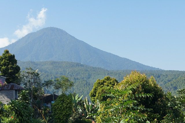
- 3. Mount Catur
- 4. Red Coral Waterfall Trail (Munduk Waterfall Trek)
- 5. Twin Lakes Hike (Buyan and Tamblingan)
- 6. West Bali National Park – Gunung Klatakan Trail
- 7. Mount Lesung
- 8. Munduk Jungle Trek
- 9. Sari Organic Walk, Ubud
- 10. Guungan Hill
- 11. Penestanan Rice Field Walk, Ubud
- 12. Lubak Mount Batur Sunrise
- Why Choose OneVasco?
- FAQs
12 Best Hiking Places in Bali
Bali’s hiking scene spans everything from active volcanoes to dense jungles. You’ll find trails for all skill levels, from easy waterfall walks to strenuous summit climbs.
Each hike offers its own unique experience, whether it’s catching a legendary sunrise or spotting rare wildlife. Let’s dive into the details of Bali’s top 12 trails.
1. Mount Batur Sunrise Trek
The Mount Batur sunrise hike is Bali’s most iconic trek. It’s a moderately challenging climb up an active volcano, with some steep and rocky sections. But the payoff is huge: watching the sun rise over Bali from the summit.
-
Difficulty: Moderate
-
Distance: 7 km short route, 11 km long route
-
Location: Kintamani, Bali
-
Cost: Rs. 2,000-3,500 per person for budget tours
-
Great for: Sunrise views, active volcanic landscapes
-
Coordinates: 8.2873° S, 115.3753° E
-
Key Tips:
-
Start hiking by 4 AM to reach the summit for sunrise
-
Bring warm layers, the summit is chilly
-
Hire a local guide for safety and navigation
-

Suggested Read: Bali in February
2. Mount Abang
For a quieter alternative to Mount Batur, try nearby Mount Abang. It’s a tougher hike through dense forest, but you’ll be rewarded with panoramic views over Lake Batur.
-
Difficulty: Moderate to challenging
-
Distance: 10-12 km round trip
-
Location: Near Bedugul
-
Cost: It’s possible to hike independently for around Rs. 1,000 (entrance fee). Guided treks cost around Rs. 3,000-4,000 per person.
-
Great for: Lake and mountain views, less crowds
-
Coordinates: 8.2833° S, 115.4333° E
-
Key Tips:
-
Hire a guide for navigation through the forest
-
Pack plenty of water and snacks
-
Expect muddy trails after the rain
-
3. Mount Catur
Mount Catur, part of the Bedugul Caldera, offers a moderate hike with lake views. Steep in parts, it’s less challenging than Batur or Agung.
-
Difficulty: Moderate
-
Distance: 8-10 km round trip
-
Location: Near Bedugul
-
Cost: Rs. 1,000 entrance fee. It’s advisable to hire a local guide (around Rs. 2,500-3,500) as the trail can be tricky to follow.
-
Great for: Lake Bratan views, moderate challenge
-
Coordinates: 8.2667° S, 115.1667° E
-
Key Tips:
-
Start early to beat the heat
-
Bring grippy shoes for steep sections
-
Enjoy views of Bedugul’s three lakes from the top
-
4. Red Coral Waterfall Trail (Munduk Waterfall Trek)
The Red Coral Waterfall Trail is one of the best hiking spots in Bali for waterfall lovers. This moderately challenging loop trail takes you past several cascades in the lush Munduk area.
-
Difficulty: Moderate
-
Distance: 4.7 km loop
-
Location: Near Buleleng
-
Cost: Parking fee of Rs. 100 per vehicle. Small donations are requested at each waterfall (Rs. 100-200).
-
Great for: Waterfall views, jungle scenery
-
Coordinates: 8.2667° S, 114.9333° E
-
Key Tips:
-
Wear shoes with good traction for slippery sections
-
Bring cash for waterfall entry fees
-
Cool off with a swim at the falls
-
5. Twin Lakes Hike (Buyan and Tamblingan)
The Twin Lakes Hike takes you along the shores of Lake Buyan and Lake Tamblingan in Bedugul. It’s an easy to moderate trek with beautiful lake and jungle views.
-
Difficulty: Easy to moderate
-
Distance: 6-8 km round trip
-
Location: Bedugul
-
Cost: Rs. 1,000 entrance fee per person.
-
Great for: Lake scenery, birdwatching
-
Coordinates: 8.2833° S, 115.1667° E
-
Key Tips:
-
Bring binoculars for spotting birds
-
Visit in the dry season (April-September) for the best weather
-
Stop by Ulun Danu Beratan Temple on Lake Bratan
-
6. West Bali National Park – Gunung Klatakan Trail
For a wilder hiking experience, head to West Bali National Park. The challenging Gunung Klatakan Trail takes you deep into the jungle, with the chance to spot birds and monkeys.
-
Difficulty: Challenging
-
Distance: 10-15 km round trip
-
Location: West Bali National Park
-
Cost: National park entrance fee of Rs. 2,500 per person. Obligatory guide costs around Rs. 10,000 per day.
-
Great for: Birdwatching, jungle trekking
-
Coordinates: 8.1833° S, 114.4833° E
-
Key Tips:
-
Hire a park guide for navigation and wildlife spotting
-
Bring plenty of water, snacks, and sun protection
-
Look out for the rare Bali starling
-
7. Mount Lesung
Mount Lesung is a less-visited peak near Bedugul, offering a moderately challenging hike and scenic views. You’ll trek through the forest and past small farms.
-
Difficulty: Moderate to challenging
-
Distance: 8-10 km round trip
-
Location: Near Bedugul
-
Cost: Free. You can hike independently or hire a local guide for around Rs. 1,500-2,500.
-
Great for: Panoramic views, less crowds
-
Coordinates: 8.2833° S, 115.1667° E
-
Key Tips:
-
Hire a guide for navigation
-
Start early to avoid the midday heat
-
Enjoy views of Bedugul and the coast from the summit
-
8. Munduk Jungle Trek
The Munduk Jungle Trek takes you through the dense forests and rolling hills of Munduk. You’ll pass by clove and coffee plantations, small villages, and several waterfalls.
-
Difficulty: Moderate
-
Distance: 6-8 km round trip
-
Location: Munduk
-
Cost: Many hikes can be done independently for free. Guided treks cost around Rs. 2,000-4,000 per person.
-
Great for: Jungle immersion, waterfall views
-
Coordinates: 8.2667° S, 114.9333° E
-
Key Tips:
-
Wear sturdy shoes for muddy trails
-
Bring a refillable water bottle
-
Visit the giant banyan tree, Bali’s oldest
-

9. Sari Organic Walk, Ubud
For an easy, educational hike, try the Sari Organic Walk in Ubud. This gentle trail takes you through organic farms and rice fields, with the chance to learn about local farming.
-
Difficulty: Easy
-
Distance: 3-4 km
-
Location: Ubud
-
Cost: Free
-
Great for: Rice field scenery, organic farming
-
Coordinates: 8.6500° S, 115.2667° E
-
Key Tips:
-
Visit in the morning or late afternoon to avoid the heat
-
Bring cash to purchase organic snacks or drinks
-
Chat with farmers to learn about their crops and methods
-
10. Guungan Hill
Guungan Hill is a short but sweet hike in Ubud, with rice fields and jungle views. It’s a great option if you’re short on time or energy.
-
Difficulty: Easy to moderate
-
Distance: 2-4 km round trip
-
Location: Near Ubud
-
Cost: Rs. 500 entrance fee.
-
Great for: Quick nature escape, rice field views
-
Coordinates: 8.6500° S, 115.2667° E
-
Key Tips:
-
Go early or late for the best light
-
Bring water and sun protection
-
Enjoy views of Mount Agung on a clear day
-
11. Penestanan Rice Field Walk, Ubud
The Penestanan Rice Field Walk is a pleasant stroll through Ubud’s iconic rice terraces. You’ll walk past small farms and get a glimpse of rural Balinese life.
-
Difficulty: Easy
-
Distance: 2-3 km
-
Location: Ubud
-
Cost: Free, donations appreciated
-
Great for: Rice terrace scenery, local culture
-
Coordinates: 8.6500° S, 115.2667° E
-
Key Tips:
-
Visit in the early morning or late afternoon for the best light
-
Wear comfortable shoes and sun protection
-
Be respectful of farmers’ crops and property
-
12. Lubak Mount Batur Sunrise
The Lubak Mount Batur Sunrise hike is an alternative route up Batur, starting from a different point but offering similar sunrise views from the summit.
-
Difficulty: Moderate
-
Distance: Around 7 km round trip
-
Location: Near the main Mount Batur trek
-
Cost: Rs. 2,000-3,500 for budget tours
-
Great for: Sunrise views, volcanic landscapes
-
Coordinates: 8.2873° S, 115.3753° E
-
Key Tips:
-
Hire a local guide for safety
-
Bring a headlamp and warm layers
-
Enjoy a breakfast cooked in volcanic steam at the top
-
Why Choose OneVasco?
OneVasco makes visa applications effortless. Our expert team manages the entire process, allowing you to focus on your journey.
Enjoy stress-free travel with fast visa approvals.
-
Expert and Personalized Support
-
Efficient and Hassle-Free Process
-
Real-Time Tracking and Updates
-
Transparent Communication
-
Trusted by Millions
FAQs
What are the different types of hiking trails in Bali?
Bali offers several types of hiking trails:
-
Volcano treks: Like Mount Batur and Mount Agung, these challenging hikes reward you with sunrise views and lunar landscapes.
-
Jungle treks: Trails like the West Bali National Park and Munduk Jungle Trek immerse you in dense rainforest, with the chance to spot wildlife.
-
Waterfall hikes: Munduk’s Red Coral Waterfall Trail and other routes take you past cascading falls in lush jungle settings.
-
Rice field walks: Easy strolls like the Campuhan Ridge Walk and Ubud’s Kajeng Trail wind through emerald-green rice terraces.
What is the best time for hiking in Bali?
The best time to hike in Bali is April to September, with cooler weather and better trail conditions. Volcano hikes are ideal for clear sunrises, while waterfalls are more spectacular in the wet season, though with rain and leeches.
What is the longest trail in Bali?
Bali’s longest hike is the 19-21 km Mount Agung trek. Most other trails range from 2 to 10 km, with multi-day hikes requiring overnight camping or combining routes.
Which trail has the most elevation gain in Bali?
Mount Agung offers the highest elevation gain in Bali, climbing 1,900 m to its 3,031 m summit. Other steep hikes include Mount Batur (1,000 m), Mount Abang (1,200 m), and Mount Catur (700 m).
What is the most popular and difficult trail in Bali?
-
Most popular hike: Mount Batur sunrise trek, a challenging yet achievable climb for most with decent fitness.
-
Most difficult hike: Mount Agung summit trek, a steep, grueling climb to Bali’s highest peak (3,031 m), requiring good fitness, an experienced guide, and 6-8 hours.
Are there camping trails available in Bali?
Yes, there are a few trails in Bali that allow camping. Some options:
-
Mount Agung: Camp at the summit for sunrise
-
West Bali National Park: Jungle camp on the Gunung Klatakan Trail
-
Mount Abang: Set up a tent on the crater rim
-
Mount Batukaru: Overnight at the summit for sunrise
Are there running trails available in Bali?
While there are no designated running trails, many of Bali’s hiking routes are suitable for trail running. Some good options:
-
Campuhan Ridge Walk: 2 km one-way path with rice field views
-
Tegal Wangi Beach Trail: 1 km coastal track in Jimbaran
-
Ayung Ridge Walk: 7 km ridge run through the jungle near Ubud
-
Mount Batur: 5 km ascent for a challenging volcano run
Are there biking trails available in Bali?
Bali’s growing mountain biking scene offers trails for all levels, including Bali Bike Park’s 30 km trails, Mount Batur’s challenging lava fields, West Bali National Park’s jungle tracks, and scenic rides through Jatiluwih Rice Terraces. Bikes and guided rides are available in Bali’s main hubs, complementing the island’s popular hiking in Bali.


