


Malta is a compact Mediterranean paradise that packs a remarkable punch for walkers. The island nation delivers walking experiences for every fitness level, from gentle coastal strolls to more challenging ridge hikes.
Hiking in Malta rewards you with dramatic limestone cliffs, pristine coastlines, rural countryside, and thousands of years of visible history—all in an area you can cross in about an hour by car.
What makes hiking in Malta particularly special is how these trails connect natural beauty with cultural heritage. Many routes pass ancient temples, historic fortifications, and traditional villages that tell the story of this crossroads of Mediterranean civilizations.
10 Best Hiking Places in Malta
- 1. Dingli Cliffs to Blue Grotto
- 2. Marfa Ridge Walk
- 3. Xemxija Heritage Trail (Old Roman Road) to Golden Bay
- 4. Popeye Village to Golden Bay
- 5. Għar Lapsi to Blue Grotto
- 6. Il-Majjistral Nature & History Park
- 7. Victoria Lines
- 8. Tas-Silġ Walk
- 9. Ħaż-Żebbuġ Heritage Trail
- 10. Girgenti Walk
- Why Choose OneVasco?
- FAQs
1. Dingli Cliffs to Blue Grotto

The Dingli Cliffs to Blue Grotto trail showcases Malta’s most dramatic coastal scenery. This path takes you along Malta’s highest point and down to one of its most photographed sea caves.
Along the way, you’ll pass ancient temples, rural farmland, and jaw-dropping sea views.
-
Difficulty: Moderate (some scrambling, exposed cliff sections)
-
Distance: 13.1 km
-
Location: Southwestern Malta, starting at Dingli Cliffs, ending at Blue Grotto (Wied iż-Żurrieq)
-
Cost: Free
-
Great for: Photography enthusiasts, history buffs, nature lovers, couples seeking romantic views
-
Coordinates: Start: 35.8570°N, 14.3851°E (Dingli Cliffs)
-
Key Tips:
-
Start early (7-8 AM) to avoid midday heat
-
Bring at least 2 liters of water
-
Wear sturdy hiking shoes
-
Don’t miss the Hagar Qim temple complex en route
-
Bus routes 201, 52, and 201 serve the start/end points
-
Suggested Read: Malta Visa Rejection For Indian Tourists
2. Marfa Ridge Walk

The Marfa Ridge Walk offers breathtaking views across to the Gozo and Comino islands. This northern route takes you through rugged Mediterranean scrubland, past historic sites, and alongside dramatic coastal cliffs.
The Marfa Peninsula trail is one of the most peaceful and famous hiking spots in Malta.
-
Difficulty: Easy to Moderate
-
Distance: 12 km (loop)
-
Location: Northern Malta, starting at Ghadira Bay
-
Cost: Free
-
Great for: Families, bird watchers, couples, photographers, small groups
-
Coordinates: 35.9804°N, 14.3672°E (Ghadira Bay)
-
Key Tips:
-
Look out for the Red Tower (St. Agatha’s Tower) – climb it for panoramic views
-
Bring binoculars for birdwatching
-
Visit the Coral Lagoon
-
Buses 41 and 42 go to the Mellieha/Ghadira area
-
Suggested Read: Malta Visa Photo Requirements For Indian Tourists
3. Xemxija Heritage Trail (Old Roman Road) to Golden Bay

Step back in time on this fascinating historical trail. The Xemxija Heritage Trail follows an ancient Roman road past 4,000-year-old apiaries (beehives), Roman baths, and prehistoric tombs before reaching the golden sands of Golden Bay.
This route is among the most culturally rich free hiking trails in Malta.
-
Difficulty: Easy
-
Distance: 8 km
-
Location: Northwest Malta, from Xemxija to Golden Bay
-
Cost: Free
-
Great for: History enthusiasts, families, casual walkers, archaeology fans
-
Coordinates: Start: 35.9401°N, 14.3666°E (Xemxija)
-
Key Tips:
-
Download the Heritage Trail map from the Visit Malta website
-
Bring water and snacks
-
Explore the Roman-era cave dwellings
-
Buses 223 and 225 connect to the trail
-
Suggested Read: Malta Visa for Indians
4. Popeye Village to Golden Bay

This picturesque coastal walk takes you from the famous Popeye Village film set (built for the 1980 Robin Williams movie) to the sandy shores of Golden Bay.
The trail hugs the coastline with spectacular views of Mellieha Bay and passes several small, secluded coves perfect for a quick swim. This is one of the most family-friendly hiking trails for couples in Malta.
-
Difficulty: Easy
-
Distance: 5.5 km
-
Location: Northwest Malta, from Popeye Village to Golden Bay
-
Cost: Free (Popeye Village entrance not included – €15/adult (approximately ₹1,350))
-
Great for: Movie fans, families with children, photographers, casual walkers
-
Coordinates: 35.9566°N, 14.3458°E (Popeye Village)
-
Key Tips:
-
This trail is ideal for sunset walks
-
Bring swimwear for the beaches en route
-
Combine with a visit inside Popeye Village (open 9:30 AM-5:30 PM)
-
Buses 101, 42 serve the area
-
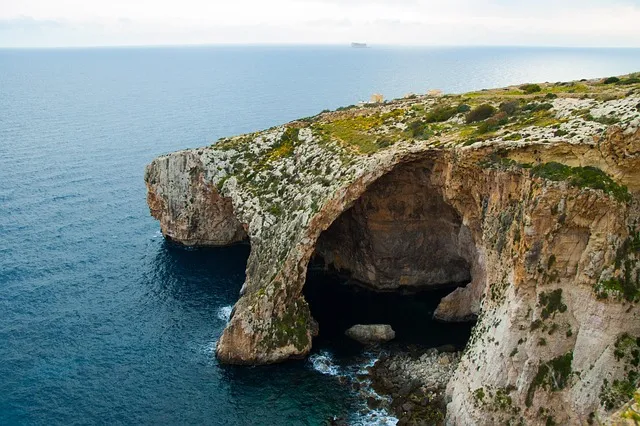
5. Għar Lapsi to Blue Grotto

This rugged coastal trail connects two of Malta’s most spectacular sea grottos. It offers some of the clearest views of the tiny island of Filfla.
Starting at the small fishing village of Għar Lapsi, the path weaves along limestone cliffs, revealing hidden coves and dramatic rock formations before reaching the tourist hotspot of Blue Grotto.
-
Difficulty: Moderate
-
Distance: 7 km (one way)
-
Location: Southwestern Malta, from Għar Lapsi to Blue Grotto
-
Cost: Free
-
Great for: Adventurers, photographers, strong swimmers, nature enthusiasts
-
Coordinates: Start: 35.8347°N, 14.4293°E (Għar Lapsi)
-
Key Tips:
-
Wear proper hiking shoes – the terrain is rocky
-
Start early to avoid the afternoon heat
-
Bring a camera for incredible sea views
-
Don’t miss swimming at Għar Lapsi’s natural pool
-
Bus 109 serves Għar Lapsi
-
Suggested Read: How to Book Malta Visa Appointment
6. Il-Majjistral Nature & History Park

Malta’s first natural national park offers multiple trails through protected coastal landscapes. The park contains diverse Mediterranean flora and fauna, limestone cliffs, boulder fields, and several small beaches.
History buffs will appreciate the WWII-era pillboxes and ancient cart ruts scattered throughout. This area is perfect for group hiking in Malta.
-
Difficulty: Easy to Moderate
-
Distance: Various trails, up to 6 km
-
Location: Northwest Malta, near Mellieha
-
Cost: Free
-
Great for: Wildlife enthusiasts, families, bird watchers, photographers, and educational groups
-
Coordinates: 35.9574°N, 14.3317°E
-
Key Tips:
-
Stay on marked trails to protect vegetation
-
Bring binoculars for birdwatching
-
Check the park website for guided walks (often free)
-
Visit Golden Bay Beach after your hike
-
Buses 44, 101, and 225 serve the area
-
Suggested Read: Temples in Malta
7. Victoria Lines

Known as the “Great Wall of Malta,” the Victoria Lines is a 12 km defensive wall built by the British in the late 19th century. This historical fortification runs along a natural geographical fault, offering panoramic views across much of northern Malta.
The trail follows the wall, passing through various landscapes and historical sites.
-
Difficulty: Easy to Moderate
-
Distance: 12 km (full length)
-
Location: Northern Malta, from Rabat to Madliena
-
Cost: Free
-
Great for: History buffs, photography enthusiasts, military history fans, experienced hikers
-
Coordinates: 35.9035°N, 14.3788°E (central point)
-
Key Tips:
-
Poor signage – download a map beforehand
-
Some sections require scrambling
-
Walk east to west for better views
-
Long pants recommended as some areas are overgrown
-
Various buses serve different sections
-
Suggested Read: How to Check Malta Visa Status Online for Indians
8. Tas-Silġ Walk

This southeastern coastal walk combines archaeology, rural scenery, and sea views. The trail passes the important Tas-Silġ archaeological site – a multi-period sanctuary used by various civilizations from 3000 BCE to 1000 CE.
The route continues through farmland and ends near the fishing village of Marsaxlokk with its colorful traditional boats.
-
Difficulty: Easy to Moderate
-
Distance: 6 km
-
Location: Southeastern Malta, around Marsaxlokk and Tas-Silġ archaeological site
-
Cost: Free
-
Great for: Archaeology enthusiasts, history lovers, photographers, food lovers (for fresh seafood)
-
Coordinates: 35.8416°N, 14.5660°E
-
Key Tips:
-
Visit the ancient temple site
-
Wear sturdy shoes for uneven paths
-
Finish with a seafood meal in Marsaxlokk
-
Sunday fish market is a must-see
-
Buses 81, 85 serve the area
-
Suggested Read: Nightlife in Malta
9. Ħaż-Żebbuġ Heritage Trail
This urban heritage walk explores one of Malta’s oldest and most traditional towns. Ħaż-Żebbuġ dates back to the Bronze Age and features magnificent Baroque architecture, narrow winding streets, and numerous historical buildings.
The trail passes the impressive St. Philip’s Church, old palaces, and traditional Maltese townhouses.
-
Difficulty: Easy
-
Distance: 5 km
-
Location: Central Malta, around Żebbuġ village
-
Cost: Free
-
Great for: Cultural explorers, architecture enthusiasts, photographers, history lovers
-
Coordinates: 35.8747°N, 14.4417°E
-
Key Tips:
-
Visit during the festa season (summer) to see street decorations
-
Try local pastries at traditional bakeries
-
Walking maps are available at the local council office
-
Buses 61, 62, 63 serve Ħaż-Żebbuġ
-
Suggested Read: India e-Visa for Malta Citizens
10. Girgenti Walk

This peaceful countryside trail explores the fertile Girgenti valley and passes the summer residence of the Archbishop of Malta. The area is known for its agricultural terraces, olive groves, and rural tranquility.
The path offers nice views of Verdala Palace, built by Grand Master de Verdalle in the 16th century.
-
Difficulty: Moderate
-
Distance: 7 km
-
Location: Central Malta, Girgenti valley area
-
Cost: Free
-
Great for: Nature lovers, photographers, history buffs, peaceful walks away from crowds
-
Coordinates: 35.8490°N, 14.4190°E
-
Key Tips:
-
The Trail can be muddy after rain
-
Spring brings beautiful wildflowers
-
Combine with a visit to nearby Buskett Gardens
-
Look for local produce stands
-
Bus 201 serves the area
-
Suggested Read: Winter in Malta
Why Choose OneVasco?
OneVasco makes visa applications effortless. Our expert team manages the entire process, allowing you to focus on your journey.
Enjoy stress-free travel with fast visa approvals.
-
Expert and Personalized Support
-
Efficient and Hassle-Free Process
-
Real-Time Tracking and Updates
-
Transparent Communication
-
Trusted by Millions
FAQs
What are the different types of hiking trails in Malta?
Malta has coastal, countryside, historical, and urban hiking trails. Dingli Cliffs offer sea views. Baħrija and Girgenti show rural life. Victoria Lines and Xemxija explore history. Urban walks reveal old architecture.
What is the best time for hiking in Malta?
The best time for hiking in Malta is from October to May. The weather is cool and pleasant. Spring (March-May) offers wildflowers and green landscapes. Winter (December-February) is mild with some rain. Summer (June-September) brings intense heat (30-35°C) and strong sun. Early morning starts (6-8 AM) are recommended year-round.
What is the longest trail in Malta?
The Victoria Lines is the longest continuous trail at 12 km, running across the width of Malta. For multi-day hiking, the Gozo Coastal Walk is longer at approximately 50 km, circling Malta’s sister island of Gozo. The Dingli Cliffs to Blue Grotto route (13.1 km) is technically longer than the Victoria Lines but follows a less defined path.
Which trail has the most elevation gain in Malta?
The Dingli Cliffs trail has the most elevation gain in Malta, reaching 253 meters. It includes several steep ascents. Baħrija Walk also has elevation changes. Terrain is rocky and can be challenging despite modest height.
What is the most popular and difficult trail in Malta?
The Dingli Cliffs to Blue Grotto trail is the most popular and challenging for hiking in Malta. It offers sea views and historic sites. Cliff edges, rough paths, and no shade add difficulty. The Victoria Lines trail is harder.
Are there camping trails available in Malta?
Camping trails in Malta are limited. Wild camping is prohibited. Permitted camping is allowed in Mellieha and L-Ahrax with permits. Contact Malta Tourism Authority. Most hikers choose guesthouses or return after day hikes.
Are there running trails available in Malta?
Yes, many hiking trails in Malta are great for running. Sliema-St. Julian’s offers a flat coastal run. Il-Majjistral has dirt paths. Salina Bay and Buskett Gardens are scenic. Start early and carry water.
Are there biking trails available in Malta?
Yes, biking is possible while hiking in Malta. The Buskett and Victoria Lines suit mountain biking. Gozo offers rural cycling routes. Bike lanes are limited. Majjistral, Dingli, and Baħrija trails allow mountain bikes. Ride with caution.


