


Slovakia sits at the heart of Europe, its landscapes packed with rugged mountains, pristine alpine lakes, and dramatic gorges. For those seeking outdoor adventure, hiking in Slovakia offers some of Europe’s most rewarding yet relatively uncrowded trails.
From the spectacular High Tatras peaks to the forest-clad valleys of Slovak Paradise, this compact country delivers world-class hiking experiences without the crowds or costs of its more famous Alpine neighbors.
12 Best Hiking Places in Slovakia
- 1. Tatranská Magistrala
- 2. Prielom Hornádu & Suchá Belá Gorge Loop
- 3. Zelene Pleso (Green Lake)
- 4. Štrbské Pleso to Popradské Pleso
- 5. Kriváň Summit
- 6. Veľký Rozsutec via Jánošíkove Diery
- 7. The Chopok Loop
- 8. Ostrá and Tlstá Circuit
- 9. Mlynická Dolina to Furkotská Dolina Loop (via Skok Waterfall)
- 10. Prosiecka and Kvačianska Valleys
- 11. Gerlachovský štít (with Guide)
- 12. Ridge Hike in the Low Tatras
- Why Choose OneVasco?
- FAQs
1. Tatranská Magistrala

The Tatranská Magistrala is Slovakia’s most iconic long-distance trail, traversing the entire spine of the High Tatras from west to east. This spectacular route passes through varied mountain landscapes, alpine meadows, and offers views of Slovakia’s highest peaks.
-
Difficulty: Hard
-
Distance: 72–73 km (official route)
-
Location: High Tatras, from Podbanské to Veľké Biele Pleso
-
Cost: Free trail access; mountain hut accommodation: €25–€50/night (INR 2,250–4,500); meals €8–€15 (INR 720–1,350) per meal; public transport to trailhead: €5–€15 (INR 450–1,350)
-
Great for: Experienced hikers, multi-day trekkers, adventure seekers, groups looking for a challenge
-
Coordinates: Start (Podbanské): 49.1275°N, 19.9806°E; End (Veľké Biele Pleso): 49.2200°N, 20.2020°E
-
Key Tips:
-
Plan for 4–5 days
-
Book mountain huts 2-3 months in advance during peak season (July-August)
-
Carry cash for huts, as card payments may be unreliable
-
Pack layers as weather changes rapidly, even in summer
-
Suggested Read: Slovakia Visa for Indians
2. Prielom Hornádu & Suchá Belá Gorge Loop
This thrilling loop in the Slovak Paradise National Park combines two of the country’s most spectacular gorge hikes. The trail features wooden ladders, metal footholds, and bridges that allow hikers to navigate directly through narrow canyons alongside rushing streams.
-
Difficulty: Moderate to challenging (due to ladders and exposure)
-
Distance: 15–18 km (loop)
-
Location: Slovak Paradise National Park, near Hrabušice
-
Cost: Park entry: €1.50–€2 (INR 135–180); parking €3–€5 (INR 270–450); equipment rental (optional gloves): €2 (INR 180)
-
Great for: Adventurous hikers, couples seeking thrills, families with teenagers
-
Coordinates: Trailhead (Podlesok): 48.9740°N, 20.3950°E
-
Key Tips:
-
Start before 9 am to avoid crowds
-
Wear sturdy, non-slip hiking shoes
-
Bring gloves for metal ladders
-
Trails through gorges are one-way only
-
Not suitable for those with a fear of heights
-
Suggested Read: Slovakia Visa Photo Requirements for Indians
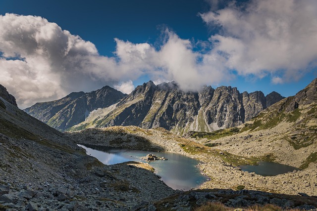
3. Zelene Pleso (Green Lake)

This classic High Tatras day hike leads to a stunning emerald-green lake surrounded by dramatic rocky peaks. The mountain hut at the lakeshore serves traditional Slovak meals, making this a perfect spot for lunch during your hike.
-
Difficulty: Moderate
-
Distance: 7.5 km (one-way)
-
Location: Eastern High Tatras, the trail starts at the Biela Voda parking
-
Cost: Free trail; parking €5 (INR 450); hut meals €8–€15 (INR 720–1,350)
-
Great for: Photographers, couples, families with older children, nature lovers
-
Coordinates: 49.2016°N, 20.1978°E
-
Key Tips:
-
Arrive by 8 am for a parking space in peak season
-
The hut serves hot food and drinks until 4 pm
-
The distinctive green color of the lake is most vibrant on sunny days
-
Worth staying overnight at the hut to experience sunrise over the lake
-
Suggested Read: How to Book a Slovakia Visa Appointment?
4. Štrbské Pleso to Popradské Pleso

This scenic route links two of the High Tatras’ most beautiful glacial lakes through gentle forest paths. It’s an excellent introduction to hiking in Slovakia for beginners or those acclimatizing to mountain conditions.
-
Difficulty: Easy to moderate
-
Distance: 4.5 km (one-way)
-
Location: High Tatras, Štrbské Pleso village
-
Cost: Free
-
Great for: Beginners, families with young children, elderly hikers, couples seeking romantic views
-
Coordinates: Start (Štrbské Pleso): 49.1221°N, 20.0597°E; End (Popradské Pleso): 49.1471°N, 20.0732°E
-
Key Tips:
-
Accessible by train directly from Poprad
-
The first portion of the path is suitable for strollers and wheelchair users
-
Visit the Symbolic Cemetery near Popradské Pleso, dedicated to victims of mountain accidents
-
Cafes at both lakes offer great mountain teas
-
Suggested Read: Austria Visa for Indians
5. Kriváň Summit

Kriváň is a national symbol of Slovakia, featured on euro coins and revered throughout the country. This distinctive peak offers a challenging day hike with panoramic views across the High and Low Tatras.
-
Difficulty: Challenging (steep, rocky upper sections)
-
Distance: 8–10 km (one-way, depending on route)
-
Location: High Tatras, trailheads at Tri Studničky or Štrbské Pleso
-
Cost: Free; parking €5 (INR 450)
-
Great for: Experienced hikers, peak baggers, patriotic Slovaks, groups with good fitness
-
Coordinates: 49.1625°N, 19.9958°E
-
Key Tips:
-
Start by 7 am to avoid afternoon thunderstorms
-
Bring at least 2 liters of water per person
-
Final ascent involves some scrambling on rocks
-
Summit can be extremely windy
-
Especially busy on August 15th (national pilgrimage day)
-
Suggested Read: Austria Visa Extension for Indians
6. Veľký Rozsutec via Jánošíkove Diery

This Malá Fatra classic combines the spectacular gorges of Jánošíkove Diery (named after a Slovak national hero similar to Robin Hood) with a dramatic summit offering 360° views of western Slovakia.
-
Difficulty: Challenging (ladders, chains, steep sections)
-
Distance: 15 km (loop)
-
Location: Malá Fatra National Park, Terchová area
-
Cost: Free; parking €3–€5 (INR 270–450)
-
Great for: Adventure seekers, couples who enjoy challenging hikes, photography enthusiasts
-
Coordinates: 49.2331°N, 19.0422°E
-
Key Tips:
-
Avoid after heavy rain, as ladders become slippery
-
Not suitable in winter without proper equipment
-
The summit ridge can be extremely windy
-
Spectacular wildflower displays in June
-
Can be combined with nearby Malý Rozsutec for a longer day
-
Suggested Read: Austria Visa Appeal For Indians
7. The Chopok Loop

Chopok is the second-highest peak in the Low Tatras, accessible via a variety of loop routes. The mountain also hosts a popular ski resort in winter, with cable cars that operate year-round.
-
Difficulty: Moderate to hard
-
Distance: 12–18 km (depending on loop chosen)
-
Location: Low Tatras, Demänovská Dolina or Trangoška
-
Cost: Free for hiking
-
Great for: Hikers of all levels (different routes available), families (via cable car), groups
-
Coordinates: 48.9458°N, 19.5931°E
-
Key Tips:
-
Cable car reduces ascent effort by over 800m elevation gain
-
The mountain hut at the summit serves hot meals and drinks
-
Weather changes rapidly even in summer
-
Excellent views of both the High Tatras and the Low Tatras from the summit
-
Suggested Read: Austria Visa Photo Size Requirement & Specification Guide
8. Ostrá and Tlstá Circuit

This loop in the Greater Fatra mountain range features two limestone peaks with dramatic cliffs and sweeping valley views. The trail passes through beautiful meadows and forests with rich wildlife.
-
Difficulty: Moderate to hard
-
Distance: 14 km (loop)
-
Location: Greater Fatra, near Blatnica village
-
Cost: Free; parking €3 (INR 270)
-
Great for: Experienced hikers, geology enthusiasts, nature lovers seeking quieter trails
-
Coordinates: Ostrá: 48.9417°N, 18.9531°E; Tlstá: 48.9394°N, 18.9633°E
-
Key Tips:
-
Some exposed ridges require caution
-
Bring plenty of water (a few springs on the route)
-
Good wildflower displays in May-June
-
Much quieter than the Tatras trails
-
Watch for grazing sheep and shepherd dogs
-
Suggested Read: How to Book an Austria Visa Appointment?
9. Mlynická Dolina to Furkotská Dolina Loop (via Skok Waterfall)

This High Tatras loop links two beautiful valleys and passes the impressive Skok Waterfall. The varied terrain makes for an interesting day hike with several distinct landscapes.
-
Difficulty: Moderate
-
Distance: 13 km (loop)
-
Location: High Tatras, from Štrbské Pleso
-
Cost: Free; parking €5 (INR 450)
-
Great for: Families with teenagers, couples, nature lovers, and waterfall enthusiasts
-
Coordinates: Skok Waterfall: 49.1572°N, 20.0606°E
-
Key Tips:
-
The waterfall is most impressive in late May/early June during snowmelt
-
Some rocky sections require careful footing
-
The trail can be busy in July-August
-
Beautiful mountain flora, especially gentians, in early summer
-
Suggested Read: Reasons for Austria Visa Rejection for Indian Nationals
10. Prosiecka and Kvačianska Valleys

This picturesque loop passes through two dramatic limestone gorges, featuring wooden ladders, historic water mills, and lush forests. The relatively gentle terrain makes it suitable for most hikers.
-
Difficulty: Moderate
-
Distance: 15 km (loop)
-
Location: Choč Mountains, near Liptovská Mara
-
Cost: Free; parking €2–€3 (INR 180–270)
-
Great for: Families, couples, photographers, history buffs interested in traditional mills
-
Coordinates: 49.1438°N, 19.4767°E
-
Key Tips:
-
The historic Oblazy water mills in Kvačianska valley date from the 18th century and are well worth exploring
-
Some wooden ladders in the Prosiecka valley may be slippery when wet
-
Local cheese producers sell products along the route in summer
-
Suggested Read: How to Check Austria Visa Status in India
11. Gerlachovský štít (with Guide)

The highest peak in Slovakia at 2,655m, Gerlachovský štít, is only accessible with a licensed mountain guide. This challenging climb requires good fitness and some technical skills.
-
Difficulty: Very hard (technical climbing required)
-
Distance: 8–10 km (round trip, varies by route)
-
Location: High Tatras, from Tatranská Polianka or Sliezsky Dom
-
Cost: Guide fee €250–€350 per group (INR 22,500–31,500); cable car/hut extra
-
Great for: Experienced hikers, mountaineers, bucket-list peak baggers
-
Coordinates: 49.1667°N, 20.1342°E
-
Key Tips:
-
Book a guide at least 2-3 months in advance for the summer season
-
Good fitness and a head for heights are essential
-
Weather can force cancellations even in summer
-
An early start (5-6 am) is recommended
-
A climbing helmet and harness are provided by guides
-
Suggested Read: India Visa for Austrian Citizens
12. Ridge Hike in the Low Tatras

The Low Tatras ridge traverse is a spectacular multi-day hike along the main mountain crest, offering panoramic views in all directions. This less-visited range provides a more solitary experience than the High Tatras.
-
Difficulty: Moderate to hard (length, exposure)
-
Distance: 55 km (from Donovaly to Telgárt)
-
Cost: Free; hut accommodation €20–€35/night (INR 1,800–3,150)
-
Location: Low Tatras National Park
-
Great for: Experienced hikers, groups, trekkers seeking multi-day adventures
-
Coordinates: Start (Donovaly): 48.8805°N, 19.2356°E; End (Telgárt): 48.8578°N, 20.1239°E
-
Key Tips:
-
Plan for 3–4 days
-
Book huts along the ridge in advance during July-August
-
Carry sufficient water between huts
-
The trail is exposed to the weather
-
Excellent chance to spot chamois, marmots, and eagles
-
Suggested Read: Best Markets in Austria
Why Choose OneVasco?
OneVasco makes visa applications effortless. Our expert team manages the entire process, allowing you to focus on your journey.
Enjoy stress-free travel with fast visa approvals.
-
Expert and Personalized Support
-
Efficient and Hassle-Free Process
-
Real-Time Tracking and Updates
-
Transparent Communication
-
Trusted by Millions
FAQs
What are the different types of hiking trails in Slovakia?
Slovakia has valley walks, ridge trails, summit hikes, gorge routes, and multi-day treks. Trails feature forests, peaks, and ladders. Color codes guide hikers—red, blue, green, and yellow mark different trail types.
What is the best time for hiking in Slovakia?
The best time for hiking in Slovakia is June to September. July-August is warm but crowded. September offers fewer people and autumn views. Early June has flowers. May and October suit lower trails, but the weather varies.
What is the longest trail in Slovakia?
Slovakia’s longest trail is the Cesta hrdinov SNP, around 770 km long. The Tatranská Magistrala spans 72–73 km across the High Tatras. It takes 4–5 days to finish.
Which trail has the most elevation gain in Slovakia?
The trail to Gerlachovský štít has the most elevation gain—up to 1,665 meters. A guide is required. Kriváň and Rysy trails also climb around 1,400 meters each. All are challenging mountain hikes.
What is the most popular and difficult trail in Slovakia?
Štrbské Pleso to Popradské Pleso is the most popular trail. It’s scenic and easy to access. Gerlachovský štít is the hardest, needing a guide. Tatranská Magistrala challenges independent hikers with length and changing weather.
Are there camping trails available in Slovakia?
Wild camping is banned in Slovak national parks. Use official campsites or mountain huts. The Low Tatras and the Slovak Paradise have campsites. Mountain huts are spaced every 4–6 hours on multi-day hikes.
Are there running trails available in Slovakia?
Yes, Slovakia has many running trails. Štrbské Pleso, Slovak Paradise, and the Lower Tatras offer great routes. Events include Tatry Running Tour and Štefánik Trail Run.
Are there biking trails available in Slovakia?
Slovakia has many biking trails, separate from steep hiking in Slovakia paths. The Low Tatras and Slovak Paradise have marked cycling routes. Jasná and Malinô Brdo offer mountain biking. The Freedom Cycle Path runs 50 km.


