


Canada’s untamed landscapes offer some of the world’s most spectacular hiking. Rugged coastlines, snow-capped peaks, glacial lakes, and old-growth forests—the country’s diverse terrain means there’s a trail for every type of hiker.
Whether you’re a seasoned trekker looking for a multi-day challenge or a casual day-tripper seeking a scenic stroll, hiking in Canada delivers. The hardest part? Narrowing down where to go. To help, we’ve rounded up 12 of the best hiking trails in Canada.
- 12 Best Hiking Places in Canada
- 1. East Coast Trail
- 2. Skyline Trail
- 3. Bruce Trail
- 4. Garibaldi Lake Trail
- 5. Lake Agnes and the Beehives
- 6. Johnston Canyon and the Ink Pots
- 7. Gros Morne Mountain Trail
- 8. Cup & Saucer Trail
- 9. Grey Owl Trail
- 10. Skerwink Trail
- 11. Pacific Crest Trail (PCT) Segment
- 12. The Great Divide Trail
- Why Choose OneVasco?
- FAQs
12 Best Hiking Places in Canada
Ready to discover some of the best hiking spots in Canada? These 12 trails showcase the country’s most stunning landscapes, from misty rainforests to rocky mountain ridges. Lace up your boots and let’s explore!
1. East Coast Trail
Hugging the rugged shores of Newfoundland, the East Coast Trail is a coastal hiker’s dream. This 300 km network of paths winds past colorful fishing villages, hidden coves, and dramatic cliffs plunging into the Atlantic.
-
Difficulty: Moderate to Difficult
-
Distance: Approximately 300 km
-
Location:Eastern coast of Newfoundland
-
Cost:Free, but some sections may require fees for parking or guide services
-
Great for:Hikers looking for a coastal hike with scenic views and diverse wildlife
-
Coordinates: Varies along the trail
-
Key Tips:
-
Be prepared for variable weather conditions, including fog and rain
-
Bring layers and waterproof gear
-
Enjoy the local culture and amenities in the coastal communities
-

Suggested Read:How to Book a Visa Appointment for Canada?
2. Skyline Trail
The Skyline Trail delivers some of Nova Scotia’s most iconic views. This scenic loop in Cape Breton Highlands National Park traverses lush river canyons and windswept headlands, with panoramas of the Gulf of St. Lawrence.
-
Difficulty: Moderate
-
Distance: 7.5 km loop
-
Location: Cape Breton Highlands National Park, Nova Scotia
-
Cost: ₹420 park entry fee
-
Great for:Panoramic coastal views (especially at sunset), fall colors, moose spotting
-
Coordinates: 46.6833° N, 60.5181° W
-
Key Tips:
-
Go clockwise for the best views on the descent
-
Watch for whales in the Gulf
-
Arrive early or late to avoid midday crowds
-
3. Bruce Trail
Canada’s oldest and longest marked footpath, the Bruce Trail traces the edge of the Niagara Escarpment through southern Ontario. Hike past waterfalls, caves, and cedar forests in this UNESCO biosphere reserve.
-
Difficulty: Easy to Difficult (varies by section)
-
Distance:Approximately 900 km
-
Location: Niagara to Tobermory, Ontario
-
Cost: Free (donations welcome), but some sections may require fees for parking or guide services
-
Great for:Hikers looking for a long-distance challenge with varied landscapes
-
Coordinates: Varies along the trail
-
Key Tips:
-
Hike in sections; arrange transportation
-
Wear sturdy footwear for rocky terrain
-
Visit in spring for flowing falls and trilliums
-
4. Garibaldi Lake Trail
The Garibaldi Lake Trail is a gem of British Columbia’s Coast Mountains. A heart-pumping climb through an old-growth forest leads to the glittering turquoise waters and glacier-clad peaks of Garibaldi Lake.
-
Difficulty: Moderate to Difficult
-
Distance: 18 km round trip
-
Location: Garibaldi Provincial Park, British Columbia
-
Cost:Free, but requires a backcountry camping permit (INR 600)
-
Great for: Alpine scenery, glacier views, wildflowers
-
Coordinates: 49.9333° N, 123.0333° W
-
Key Tips:
-
Start early to secure parking and beat the crowds
-
Bring a swimsuit for a chilly dip in the lake
-
Check trail conditions; snow lingers into July
-
Reserve campsites well in advance
-
Pack bug spray for summer mosquitoes
-

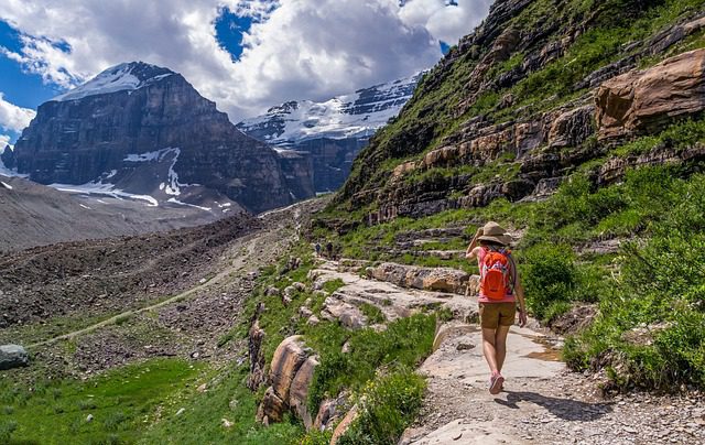
5. Lake Agnes and the Beehives
The classic Lake Agnes hike leads to one of Banff National Park’s most beloved teahouses. Continue to the Big or Little Beehive for bird’s-eye views over Lake Louise’s famed turquoise waters.
-
Difficulty: Moderate
-
Distance:7 km round trip to Lake Agnes; add approx. 1.5 km for Big Beehive
-
Location: Banff NP, Alberta
-
Cost: ₹600 park entry fee
-
Great for: Stunning lake views, Teahouse experience
-
Coordinates: 51.4167° N, 116.2333° W
-
Key Tips:
-
Arrive early to avoid crowds at Lake Agnes Tea House
-
Continue past the teahouse for Big Beehive’s stunning views
-
Be careful on the switchbacks and rocky terrain
-
Bring cash for tea and baked goods
-
6. Johnston Canyon and the Ink Pots
Walk through a water-carved canyon to a series of cascading waterfalls on this popular hike in Banff. Continue past the Upper Falls to the Ink Pots—seven vivid mineral springs bubbling from the earth.
-
Difficulty: Easy to Moderate
-
Distance: 5.2 km round trip (Upper Falls); 11.7 km (Ink Pots)
-
Location:Banff National Park, Alberta
-
Cost: ₹600 park entry fee
-
Great for: Waterfalls, unique geology, family-friendly hiking
-
Coordinates: 51.2333° N, 115.8333° W
-
Key Tips:
-
Visit early or late for fewer crowds
-
Bring cleats in winter for icy catwalks
-
Fill up water bottles at Ink Pots (safe to drink)
-
Extend your hike to Moose Meadows for a quieter trail
-
7. Gros Morne Mountain Trail
Climb to the second-highest peak in Newfoundland on this challenging trail in Gros Morne National Park. Atop this soaring plateau, hikers are rewarded with views over ancient fjords and the Gulf of St. Lawrence.
-
Difficulty: Difficult
-
Distance: 16 km round trip
-
Location:Gros Morne National Park, Newfoundland
-
Cost: ₹480 park entry fee
-
Great for: 360-degree summit views, geology, arctic-alpine plants
-
Coordinates: 49.5833° N, 57.7833° W
-
Key Tips:
-
Check the weather; conditions change quickly
-
Keep an eye out for rock ptarmigans
-
Bring layers and windproof gear for the exposed summit
-
Allow 6-8 hours to complete the hike
-
Book the Gros Morne Mountain Hiker’s Shuttle for convenient transportation
-
8. Cup & Saucer Trail
The Cup and Saucer Trail is a scenic standout on Manitoulin Island, the world’s largest freshwater island. Multiple lookouts offer far-reaching views over the island’s lush valleys, shimmering lakes, and white limestone cliffs.
-
Difficulty: Moderate
-
Distance: 12 km round trip
-
Location: Manitoulin Island, Ontario
-
Cost: Free
-
Great for:Scenic views and interesting geological features
-
Coordinates: 45.9667° N, 81.9667° W
-
Key Tips:
-
Wear sturdy shoes for rocky sections
-
Bring water and snacks, as there are no services on the trail
-
Watch your footing on the steep stairs and ladders
-
Visit in the fall for stunning autumn colors
-
Visit in autumn for blazing foliage
-
9. Grey Owl Trail
Follow in the footsteps of conservationist Archibald Belaney (aka Grey Owl) on this backcountry trail in Prince Albert National Park. Pass spruce bogs and sandy beaches en route to the log cabin of this influential early author.
-
Difficulty: Moderate to Difficult
-
Distance: 40 km round trip
-
Location:Prince Albert National Park, Saskatchewan
-
Cost: ₹480 park entry fee
-
Great for:A multi-day wilderness adventure, wildlife spotting, lakes, and Grey Owl’s cabin
-
Coordinates: 53.9667° N, 106.0667° W
-
Key Tips:
-
Allow 2-3 days for full hike
-
Practice leave-no-trace ethics
-
Reserve backcountry campsites in advance
-
Hang food and scented items to avoid attracting bears
-
Bring a fishing rod to catch your dinner in Kingsmere Lake
-
10. Skerwink Trail
The Skerwink Trail packs a scenic punch into just 5.3 km. Tracing the rocky coast of the Bonavista Peninsula, this trail delivers constant views over sea stacks, beaches, and rugged cliffs. Keep your eyes peeled for icebergs and whales!
-
Difficulty: Easy to Moderate
-
Distance: 5.3 km loop
-
Location: Port Rexton, Newfoundland
-
Cost: Free
-
Great for: Coastal scenery, photography, whales, and icebergs
-
Coordinates: 48.3867° N, 53.3269° W
-
Key Tips:
-
Visit in June or July for the best chance to spot icebergs
-
Arrive early for the best light and parking
-
Bring binoculars to see whales spouting offshore
-
Pack a picnic to enjoy on one of the beaches
-
11. Pacific Crest Trail (PCT) Segment
While most of the famous Pacific Crest Trail lies in the US, the northernmost section cuts through the glacier-clad peaks of E.C. Manning and Cathedral Provincial Parks. Hike a stretch of this legendary route through sub-alpine meadows and old-growth forests.
-
Difficulty: Moderate to Difficult
-
Distance: Varies
-
Location: Manning and Cathedral Provincial Parks, BC
-
Cost: ₹600 park fees
-
Great for: Wilderness experience, mountain views, PCT legacy
-
Coordinates: Varies
-
Key Tips:
-
Plan your hike in sections due to the trail’s length
-
Check current conditions and wildfire status before setting out
-
Hang food/use bear canisters in backcountry
-
Prepare for all weather conditions
-

12. The Great Divide Trail
One of Canada’s toughest treks, the Great Divide Trail runs 1,100 km down the spine of the Canadian Rockies. Multi-day sections dish up stunning alpine passes, jewel-toned lakes, and frequent wildlife sightings.
-
Difficulty: Difficult
-
Distance: Approximately1,100 km
-
Location: Jasper NP to Waterton Lakes NP, Alberta/BC
-
Cost: ₹600 park entry fees
-
Great for:Experienced backpackers seeking a remote wilderness challenge
-
Coordinates: Varies along the trail
-
Key Tips:
-
Plan your hike in sections due to the trail’s length
-
Bring a GPS and maps, as the trail is not always well-marked
-
Be prepared for river crossings, snow, and unpredictable mountain weather
-
Plan food drops and resupplies carefully
-
Carry bear spray and make noise on the trail
-
Why Choose OneVasco?
OneVasco makes visa applications effortless. Our expert team manages the entire process, allowing you to focus on your journey.
Enjoy stress-free travel with fast visa approvals.
-
Expert and Personalized Support
-
Efficient and Hassle-Free Process
-
Real-Time Tracking and Updates
-
Transparent Communication
-
Trusted by Millions
FAQs
What are the different types of hiking trails in Canada?
Canada offers a range of hiking experiences:
-
Day hikes: Shorter trails like Garibaldi Lake or the Skerwink Trail
-
Multi-day treks: Longer routes like the West Coast Trail or Great Divide
-
Coastal hikes: Trails along ocean cliffs and beaches, like the East Coast Trail
-
Mountain hikes: Routes in the Rockies, Coast Mountains, and other ranges
-
Backcountry hikes: Remote trails requiring wilderness skills and multi-day packs
What is the best time for hiking in Canada?
The best time for hiking in Canada varies: late June to early September offers warm, dry weather; mid-September to October is ideal for fall foliage; November to March is for snowshoeing due to snow; and April to May brings muddy trails and lingering snow at higher elevations.
What is the longest trail in Canada?
The Great Divide Trail is the longest at roughly 1,100 km. It follows the continental divide through the Canadian Rockies from Waterton Lakes National Park to Kakwa Provincial Park.
Which trail has the most elevation gain in Canada?
The West Coast Trail on Vancouver Island has one of the highest cumulative elevation gains at over 1,500 m across its 75 km length. However, many trails in the Rockies and Coast Mountains have higher elevation gains over shorter distances.
What is the most popular and difficult trail in Canada?
The West Coast Trail is both extremely popular and challenging. This 75 km trek along Vancouver Island’s remote coast requires advance reservations and tops many lists of Canada’s toughest trails.
Are there camping trails available in Canada?
Yes, many trails have backcountry campsites for overnight trips:
-
West Coast Trail: 7-8 day trek with designated campsites
-
La Cloche Silhouette Trail: 80 km loop with 7+ campsites
-
Rockwall Trail: 55+ km multi-day hike with campgrounds in Kootenay National Park
Are there running trails available in Canada?
While most trails are designed for hiking, some trails in Canada are also great for trail running. These include the 10 km Coastal Trail in East Sooke Regional Park, BC, the 20+ km Iceline Trail in Yoho National Park, BC, and over 165 km of mixed-use trails in Gatineau Park near Ottawa.
Are there biking trails available in Canada?
Yes, Canada offers numerous biking trails for all levels, alongside its renowned hiking in Canada. Notable options include the 650+ km Kettle Valley Rail Trail in southern BC, the 883 km Newfoundland T’Railway, and the expansive 24,000+ km Great Trail, which features biking sections across the country.


