Hiking in Malaysia offers a smorgasbord of adventures. The Southeast Asian nation’s diverse landscapes serve up everything from leisurely jungle strolls to strenuous summit climbs. Misty rainforests, rolling tea plantations, and craggy peaks—Malaysia’s hiking buffet will satiate any outdoor appetite.
Ready to hit the trail? We’ve rounded up 12 of the best hiking trails in Malaysia, with options for casual day-trippers to hardcore peak-baggers.
12 Best Hiking Places in Malaysia
From the highest peak in Southeast Asia to hidden urban green spaces, these are some of the most rewarding hiking spots in Malaysia. Pack your sunscreen, lace up your boots, and let’s hit the trail.
1. Mount Kinabalu
Towering 4,095 meters above the jungles of Sabah, Mount Kinabalu is the tallest mountain in Malaysia and a bucket-list trek for serious hikers.
-
Difficulty: Hard. Climbing Mount Kinabalu is physically demanding and requires a good fitness level.
-
Distance: 8.7 km one way to the summit
-
Location: Kinabalu Park, Sabah
-
Cost: Climbing permits, guide fees, and accommodation cost around INR 21,000-29,000 per person
-
Great for: Adventurers seeking a challenging climb with incredible views
-
Coordinates: 6.0752° N, 116.5583° E
-
Key Tips:
-
Book your climb well in advance as daily climber numbers are limited.
-
Be prepared for altitude and unpredictable weather.
-
Acclimatize properly, pack warm layers, and start before dawn to catch the sunrise from the summit.
-

Suggested Read:20 Vibrant Festivals in Malaysia
2. Bukit Tabur
Just a short drive from downtown Kuala Lumpur, the Bukit Tabur ridge offers a challenging day hike with panoramic views.
-
Difficulty: Moderate to Hard. Some sections require rock scrambling and a head for heights.
-
Distance: Varies, but the Bukit Tabur West trail is around 5 km
-
Location: Taman Melawati, Kuala Lumpur
-
Cost: Free, but you need to register and get a permit from the forestry department
-
Great for: Thrill-seekers and experienced hikers looking for a challenge close to the city
-
Coordinates: 3.2155° N, 101.7542° E
-
Key Tips:
-
Start early to beat the heat and crowds.
-
Wear good shoes with grip for the rocky terrain.
-
Consider hiring a guide if you’re inexperienced.
-
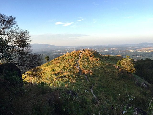
3. Broga Hill
Broga Hill’s gentle slopes and expansive views make it one of the most popular hiking spots near Kuala Lumpur, especially for catching the sunrise.
-
Difficulty: Easy to Moderate. The trail is well-maintained and not too steep.
-
Distance: 3.6 km round trip
-
Location: Semenyih, Selangor
-
Cost: Free entry. There’s a small parking fee of INR 20.
-
Great for: Novice hikers, families, and anyone wanting a quick nature escape from the city
-
Coordinates: 2.9280° N, 101.8000° E
-
Key Tips:
-
Go for sunrise to catch breathtaking views over misty hills.
-
Bring water and snacks.
-
4. Penang Hill
Penang Hill offers several hiking routes through the lush jungle up to scenic viewpoints overlooking George Town and the Straits of Malacca.
-
Difficulty: Moderate. The trails are well-marked but can be steep in parts.
-
Distance: Varies. The “Jeep Track” from the Botanical Gardens is about 4.8 km one-way.
-
Location: Air Itam, Penang
-
Cost: Free for hiking. If you don’t want to hike down, a one-way funicular train ticket is INR 140.
-
Great for: Nature lovers wanting a scenic hike and great views over Georgetown
-
Coordinates: 5.4234° N, 100.3040° E
-
Key Tips:
-
Bring plenty of water and snacks.
-
Be prepared for leeches in wetter months.
-
Follow the well-marked trail from the Botanical Gardens.
-

5. Gunung Tahan
At 2,187 meters, Gunung Tahan is Peninsular Malaysia’s highest peak and a grueling yet rewarding multi-day trek through Taman Negara National Park.
-
Difficulty: Hard. This strenuous multi-day hike requires excellent fitness and preparation.
-
Distance: Around 110 km round trip, depending on the route
-
Location: Taman Negara National Park, Pahang
-
Cost: Expect to pay around INR 29,000 per person including permits, guides, porters, and food.
-
Great for: Adventurers wanting a challenging wilderness trek into the heart of Malaysia’s jungles
-
Coordinates: 4.1761° N, 102.4184° E
-
Key Tips:
-
Arrange your trip with an experienced operator.
-
Prepare for river crossings and unpredictable weather.
-
Pack light and train extensively beforehand.
-
6. Bukit Gasing
This little-known urban forest reserve offers several short but satisfying hiking trails just minutes from downtown Kuala Lumpur.
-
Difficulty: Easy to Moderate. The trails are short but some can be steep.
-
Distance: Looping the park trails is around 3 km
-
Location: Petaling Jaya, Selangor
-
Cost: Free entry
-
Great for: City dwellers looking for a convenient taste of nature
-
Coordinates: 3.0986° N, 101.6500° E
-
Key Tips:
-
Go early to beat the crowds and heat.
-
The red trail offers some nice viewpoints.
-
Keep an eye out for monkeys and tropical birds.
-
7. Gunung Lambak
Gunung Lambak is a small but scenic peak in the heart of Johor, offering a short but steep hike through the jungle.
-
Difficulty: Moderate. The trail is straightforward but gets steep near the top.
-
Distance: Around 6 km round trip
-
Location: Kluang, Johor
-
Cost: Free
-
Great for: Hikers wanting a good workout and nice views without traveling too far
-
Coordinates: 1.4872° N, 102.0725° E
-
Key Tips:
-
Avoid the crowds and heat by starting early.
-
Bring plenty of water and snacks.
-
8. Taman Tugu
This 66-acre urban forest park offers several well-maintained hiking trails and a chance to spot some of KL’s diverse birdlife.
-
Difficulty: Easy. The trails are flat and well-maintained.
-
Distance: Various short loop trails up to 3 km
-
Location: Kuala Lumpur
-
Cost: Free entry
-
Great for: Families, casual walkers, and joggers wanting some greenery in the city
-
Coordinates: 3.1799° N, 101.6869° E
-
Key Tips:
-
Check the website for free guided walks to learn about the park’s heritage trees.
-
Visit in the early morning or late afternoon for the best bird-watching.
-
9. Gunung Jerai
Also known as Kedah Peak, Gunung Jerai is the highest point in northern Malaysia and offers a challenging day hike with views of the surrounding rice paddies and limestone hills, making it a great option for hiking in Malaysia.
-
Difficulty: Moderate. The trail is well-marked but continuously uphill.
-
Distance: About 10 km round trip
-
Location: Gurun, Kedah
-
Cost: INR 100 (entrance fee)
-
Great for: Hikers wanting a good workout and to explore some of Kedah’s nature and history
-
Coordinates: 5.6817° N, 100.4076° E
-
Key Tips:
-
Visit the archeological museum at the top to learn about Gunung Jerai’s ancient history.
-
Start early to avoid the afternoon heat.
-
Bring plenty of water and snacks.
-
10. Bukit Kutu
The trail up Bukit Kutu passes by a pretty waterfall before ascending through the forest to a peak with panoramic views.
-
Difficulty: Moderate. The hike is a steady uphill climb with some steep sections.
-
Distance: Around 10 km round trip
-
Location: Kuala Kubu Bharu, Selangor
-
Cost: Free
-
Great for: Waterfall lovers and those who like a decent workout on their hikes
-
Coordinates: 3.3272° N, 101.6450° E
-
Key Tips:
-
Wear shoes with good traction as the trail can get slippery, especially after rain.
-
11. Mount Baling
Located near the Thai border, Mount Baling offers a short but steep hike to a panoramic viewpoint overlooking the surrounding rainforest and limestone hills.
-
Difficulty: Easy to Moderate. The trail is well-trodden but has some steeper sections.
-
Distance: Around 4 km round trip
-
Location: Baling, Kedah
-
Cost: Free
-
Great for: Beginner hikers and those looking for a short sunrise hike without big crowds
-
Coordinates: 5.3187° N, 100.4898° E
-
Key Tips:
-
Bring a headlamp if you’re hiking up for sunrise.
-
Enjoy the views of Baling town and limestone hills.
-

12. FRIM Forest Skywalk
The Forest Research Institute of Malaysia (FRIM) offers several easy hiking trails through a lush forest reserve, as well as a unique canopy walkway.
Difficulty: Easy. The walkway is sturdy and flat, suitable for almost everyone.
Distance: The Skywalk is 400 m long
Location: Kepong, Kuala Lumpur
Cost: INR 200 for MyKad holders, INR 800 for non-MyKad holders
Great for: Families, kids, and those who want a forest experience without a strenuous hike
Coordinates: 3.1944° N, 101.6136° E
Key Tips:
-
Book your tickets in advance as visitor numbers are limited to reduce crowding on the walkway.
-
Visit on weekdays to avoid crowds.
Why Choose OneVasco?
OneVasco makes visa applications effortless. Our expert team manages the entire process, allowing you to focus on your journey.
Enjoy stress-free travel with fast visa approvals.
-
Expert and Personalized Support
-
Efficient and Hassle-Free Process
-
Real-Time Tracking and Updates
-
Transparent Communication
-
Trusted by Millions
FAQs
What are the different types of hiking trails in Malaysia?
Malaysia offers a wide range of hiking trails, from short nature walks to multi-day jungle treks. Some popular types include:
-
Easy nature trails in urban parks like Taman Tugu and FRIM
-
Moderate half-day or day hikes like Broga Hill and Penang Hill
-
Challenging full-day hikes like Gunung Jerai and Bukit Kutu
-
Multi-day mountain expeditions like Mount Kinabalu and Gunung Tahan
What is the best time for hiking in Malaysia?
The best time for hiking in Malaysia is from April to October during the dry season. While hiking is possible year-round, the east coast sees less rain from November to February. The shoulder months (April, May, September, and October) offer the best weather for hiking in Malaysia.
What is the longest trail in Malaysia?
The longest hike in Malaysia is the Gunung Tahan trek, a 110 km journey through Taman Negara National Park, taking 7-10 days to reach the summit of Peninsular Malaysia’s highest peak.
Which trail has the most elevation gain in Malaysia?
Mount Kinabalu has the most elevation gain of any hiking trail in Malaysia. The standard summit trail starts at Timpohon Gate (1,800 m) and climbs over 2,200 m to the summit of Low’s Peak at 4,095 m. Most hikers cover this elevation gain over 2 days.
What is the most popular and difficult trail in Malaysia?
Mount Kinabalu is one of Malaysia’s most popular and challenging hikes. With a 2,200 m+ elevation gain, it offers stunning views and attracts over 100,000 hikers yearly despite its difficulty.
Are there camping trails available in Malaysia?
Yes, many of Malaysia’s multi-day hikes, like the Gunung Tahan trek, have basic campsites while trails like Mount Kinabalu and Gunung Stong offer mountain huts with dorm beds. Wild camping is not allowed in national parks, so it’s best to stay at designated campsites or accommodations.
Are there running trails available in Malaysia?
Many trails in this guide are great for trail running, especially easier hikes like Broga Hill and Penang Hill. FRIM and Taman Tugu offer excellent forest trails, and events like the Taman Negara Run and Eco Cameron Ultra Trail are held yearly.
Are there biking trails available in Malaysia?
Yes, Malaysia has great mountain biking trails, including Kiara Trail in Kuala Lumpur, Putrajaya Challenge Park, Bukit Kiara, and Penang Hill. Trails vary in difficulty, and you can even book biking tours in places like Langkawi and Cameron Highlands. For outdoor enthusiasts, biking and hiking in Malaysia offer unforgettable adventures.