


Myanmar’s mountains, valleys, and ancient paths offer some of Asia’s most spectacular walking experiences. The country serves up a rich menu of trails that range from easy temple strolls to challenging multi-day mountain expeditions.
For Indian travellers, hiking in Myanmar presents a chance to explore landscapes quite different from home. The country boasts of pine forests, limestone peaks, alpine meadows, and remote tribal villages.
14 Best Hiking Places in Myanmar
- 1. Kalaw to Inle Lake Trek
- 2. Mount Victoria (Nat Ma Taung) National Park
- 3. Mount Zwegabin (Hpa An)
- 4. Hsipaw Hill Tribe Trek
- 5. Putao & Hkakabo Razi Base Trek
- 6. Chin Hills & Tribes Trek
- 7. Trek to Hti Ne (Pa’O Countryside)
- 8. Kyaiktiyo Pagoda (Golden Rock) Hike
- 9. Mandalay Hill
- 10. Pyin Oo Lwin & Peik Chin Myaung Cave
- 11. Pindaya Cave Trek
- 12. Temple Walks in Bagan
- 13. Viewpoint Trek (Kalaw)
- 14. Mount Popa
- Why Choose OneVasco?
- FAQs
1. Kalaw to Inle Lake Trek

This multi-day journey ranks as the most popular trek in Myanmar, connecting the colonial hill station of Kalaw with the stunning Inle Lake. The route winds through pine forests, tea plantations, and villages of the Pa’O, Danu, and Palaung ethnic groups.
-
Difficulty: Moderate
-
Distance: 57-60 km (2-3 days)
-
Location: Shan State, starting from Kalaw town and ending at Inle Lake
-
Cost: 40,000-70,000 Kyat (approximately ₹1,200-₹2,100) per person, including guide, meals, and homestays
-
Great for: First-time trekkers, culture seekers, photographers, couples looking for a romantic adventure
-
Coordinates: Kalaw (20.6311° N, 96.5610° E), Inle Lake (20.6617° N, 96.9316° E)
-
Key Tips:
-
Book with a local guide who speaks English
-
Bring sun protection and a good hat; wear layers as mornings can be chilly
-
Carry a small daypack with essentials
-
Most treks include homestays in Pa’O, Danu, or Palaung villages
-
Suggested Read: Myanmar Visa for Indians
2. Mount Victoria (Nat Ma Taung) National Park

Mount Victoria (locally known as Nat Ma Taung) rises 3,053 metres above sea level in Myanmar’s remote Chin State. The national park surrounding this peak offers several hiking options through cloud forests rich with rare birds and orchids.
-
Difficulty: Challenging
-
Distance: 16 km round trip for summit trek; longer multi-day options available
-
Location: Chin State, accessible from the towns of Kanpetlet or Mindat
-
Cost: Park entrance fee 10,000 Kyat (₹300); guided multi-day treks 120,000-200,000 Kyat (₹3,600-₹6,000)
-
Great for: Birdwatchers, nature enthusiasts, serious hikers, small groups looking for wilderness
-
Coordinates: 21.2278° N, 93.9842° E
-
Key Tips:
-
Bring warm clothing as temperatures drop significantly at night
-
November-February offers the best weather and clearest views
-
Local guides are mandatory for longer routes
-
Accommodation in nearby towns is basic
-
Suggested Read: Myanmar Visa Rejection for Indians
3. Mount Zwegabin (Hpa An)

This striking limestone mountain rises dramatically from the plains near Hpa An, topped with a golden pagoda and monastery. The steep climb rewards hikers with panoramic views across Kayin State’s karst landscape.
-
Difficulty: Moderate to Strenuous
-
Distance: 7 km round trip
-
Location: Kayin State, near the town of Hpa An
-
Cost: Free (donations at the monastery appreciated)
-
Great for: Day-trippers, photographers, sunrise/sunset chasers, couples seeking romantic views
-
Coordinates: 16.8149° N, 97.6731° E
-
Key Tips:
-
Start very early (5:30-6:00 am) to avoid midday heat
-
Bring at least 2 litres of water per person
-
Stairs can be slippery in the wet season
-
Modest dress is required at the monastery
-
Monkeys along the route can be aggressive if you have food visible
-
Suggested Read: India Visa Photo Requirements for Tourists for Myanmar Citizens (Residing in KSA)
4. Hsipaw Hill Tribe Trek
The hills surrounding Hsipaw offer excellent opportunities for short and multi-day treks through Shan villages, tea plantations, and bamboo forests. These walks provide authentic glimpses of rural life in Myanmar’s northeastern regions.
-
Difficulty: Moderate
-
Distance: 20-38 km (1-3 days depending on route)
-
Location: Shan State, starting from Hsipaw town
-
Cost: 25,000-60,000 Kyat (₹750-₹1,800) including guide, meals, and accommodation
-
Great for: Cultural immersion, village homestays, photographers, small groups
-
Coordinates: 22.6191° N, 97.3006° E
-
Key Tips:
-
Several route options are available based on fitness level
-
October-March offers pleasant temperatures
-
Bring small gifts for homestay hosts (school supplies are appreciated)
-
Check current travel advisories, as some areas have access restrictions
-
Suggested Read: How to Check India Visa Status For Myanmar Citizens (Residing in KSA)
5. Putao & Hkakabo Razi Base Trek

The remote northern region of Kachin State offers Myanmar’s most challenging trekking. Expeditions from Putao town take you toward Hkakabo Razi, Southeast Asia’s highest peak at 5,881 metres.
-
Difficulty: Very Challenging
-
Distance: 50+ km for shorter routes; 200+ km for full base camp expeditions
-
Location: Kachin State, Northern Myanmar, starting from Putao town
-
Cost: High (guided expeditions starting from ₹75,000, with permits and transport exceeding ₹150,000 for longer trips)
-
Great for: Experienced mountaineers, adventure seekers, wilderness enthusiasts
-
Coordinates: Putao (27.3296° N, 97.4264° E)
-
Key Tips:
-
Special permits required
-
Book with established expedition companies
-
The best season is November-February
-
Prepare for basic conditions and variable weather
-
Requires excellent fitness and previous high-altitude experience
-
Minimum 2-week commitment for even shorter routes
-
6. Chin Hills & Tribes Trek

The Chin Hills offer culturally rich trekking through remote villages where you may encounter women with traditional facial tattoos. The region provides insight into one of Myanmar’s most distinctive ethnic cultures.
-
Difficulty: Intermediate to Challenging
-
Distance: Approximately 16 km per day on multi-day routes
-
Location: Chin State, various routes from Mindat or Kanpetlet
-
Cost: 80,000-150,000 Kyat (₹2,400-₹4,500) for guided multi-day treks
-
Great for: Cultural explorers, photographers, those seeking authentic experiences
-
Coordinates: Mindat (21.3685° N, 93.9534° E)
-
Key Tips:
-
Trails pass through pristine forests and remote villages
-
Local guides are essential for communication and cultural context
-
Overnight stays are usually in local homes with basic facilities
-
November-February offers the best trekking conditions
-
Bring warm clothing for cool nights
-
Suggested Read: How to Check Myanmar Visa Status Online for Indians?
7. Trek to Hti Ne (Pa’O Countryside)
This lesser-known trek near Kalaw takes you through the Pa’O countryside, away from the more popular routes. You’ll walk through agricultural landscapes, small villages, and forest areas rarely visited by tourists.
-
Difficulty: Easy to Moderate
-
Distance: 20-25 km (typically a 2-day trek)
-
Location: Shan State, starting near Kalaw
-
Cost: 40,000-50,000 Kyat (₹1,200-₹1,500)
-
Great for: Those seeking solitude, sustainable tourism supporters, and photographers
-
Coordinates: Approximately 20.6311° N, 96.5610° E
-
Key Tips:
-
Organized through Community Involved Tourism (CIT) initiatives
-
Significantly fewer tourists than on the Inle Lake trek
-
Authentic homestay experiences
-
Bring a headlamp as villages have limited electricity
-
Respectful dress is recommended when visiting Pa’O communities
-
Suggested Read: Festivals in Myanmar
8. Kyaiktiyo Pagoda (Golden Rock) Hike

The pilgrimage route to the famous Golden Rock offers a spiritual hiking experience. This giant boulder perched precariously on a cliff edge, topped with a small pagoda, is one of Myanmar’s most sacred sites.
-
Difficulty: Moderate
-
Distance: 10 km round trip from the base camp
-
Location: Mon State
-
Cost: Free to hike; entrance fee to pagoda area 10,000 Kyat (₹300)
-
Great for: Religious pilgrims, photographers, cultural explorers, day hikers
-
Coordinates: 17.4812° N, 97.0987° E
-
Key Tips:
-
Start early in the morning to avoid crowds
-
The trail is steep but well-maintained with concrete steps
-
Women are not allowed in some sections of the pagoda area
-
Option to ride a truck partway for those with limited mobility
-
Modest dress required
-
Particularly busy during Buddhist holidays
-
9. Mandalay Hill

This iconic hill in the heart of Mandalay offers a pleasant urban hike with cultural significance. The climb takes you past numerous pagodas and shrines before rewarding you with panoramic city views.
-
Difficulty: Easy
-
Distance: 2 km one way
-
Location: Mandalay City
-
Cost: Free (small donations at shrines appreciated)
-
Great for: Urban explorers, families, photography enthusiasts, sunset viewers
-
Coordinates: 21.9980° N, 96.0960° E
-
Key Tips:
-
Well-marked paths and stairways
-
Shoes must be removed throughout the climb as it’s a religious site
-
Sunset offers the best views and cooler temperatures
-
The southern stairway is covered and more comfortable
-
Allow 30-45 minutes for the ascent
-
Bring a torch if descending after dark
-
Suggested Read: Beaches in Myanmar
10. Pyin Oo Lwin & Peik Chin Myaung Cave

The former British hill station of Pyin Oo Lwin offers pleasant walks through botanical gardens, while nearby Peik Chin Myaung Cave presents an interesting underground hiking experience.
-
Difficulty: Easy
-
Distance: 1-5 km (variable walks)
-
Location: Mandalay Region
-
Cost: Gardens entry 5,000 Kyat (₹150); Cave entry 1,000 Kyat (₹30)
-
Great for: Families, casual walkers, nature lovers, photography enthusiasts
-
Coordinates: 22.0341° N, 96.4566° E
-
Key Tips:
-
Combine botanical garden walks with the limestone cave exploration
-
The cave floor can be slippery, so wear appropriate footwear
-
Bring a light jacket as the cave is cool inside
-
The area enjoys a cooler climate than lowland Myanmar
-
Easily accessible as a day trip from Mandalay
-
11. Pindaya Cave Trek

The limestone cave system near Pindaya contains thousands of Buddha images and can be approached via several trekking routes through the surrounding Shan countryside.
-
Difficulty: Moderate
-
Distance: Variable (day hikes or multi-day options from Kalaw)
-
Location: Shan State
-
Cost: Cave entrance 3,000 Kyat (₹90); guided treks 30,000-60,000 Kyat (₹900-₹1,800)
-
Great for: Cave enthusiasts, Buddhist culture explorers, photographers
-
Coordinates: 20.9936° N, 96.6677° E
-
Key Tips:
-
The cave itself houses over 8,000 Buddha images
-
Surrounding trails offer pleasant day hiking through farmland and villages
-
Can be combined with Kalaw treks for longer experiences
-
A modest dress is required for the cave visit
-
Some sections of the cave are narrow and require ducking
-
Suggested Read: Nightlife in Myanmar
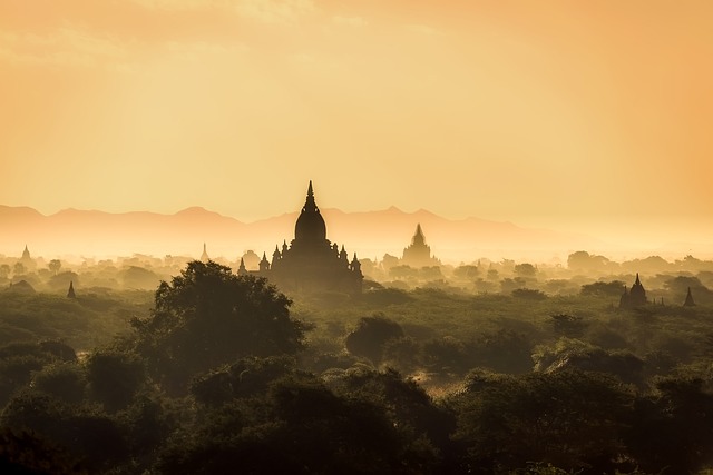
12. Temple Walks in Bagan

While not traditional hiking, exploring Bagan’s vast temple complex on foot offers an atmospheric walking experience through one of Asia’s most remarkable archaeological zones.
-
Difficulty: Easy
-
Distance: Flexible (walks between temples 1-10 km)
-
Location: Bagan, Mandalay Region
-
Cost: Bagan Archaeological Zone fee 25,000 Kyat (₹750)
-
Great for: History enthusiasts, photographers, casual walkers
-
Coordinates: 21.1717° N, 94.8585° E
-
Key Tips:
-
Start very early morning to avoid the heat and catch the sunrise
-
Bring a good map, as some temples are hard to find
-
Wear appropriate clothes for entering sacred sites (shoulders and knees covered)
-
Climbing most temples is now prohibited, but designated viewing platforms exist
-
Bring plenty of water; consider renting an e-bike to reach more distant temples
-
Suggested Read: Solo Travel in Myanmar
13. Viewpoint Trek (Kalaw)

This popular day hike from Kalaw takes you to a scenic viewpoint overlooking the surrounding hills and valleys of Shan State. It’s perfect for those with limited time but who still want a taste of hiking in Myanmar.
-
Difficulty: Easy to Moderate
-
Distance: 8-12 km round trip
-
Location: Near Kalaw, Shan State
-
Cost: 10,000-15,000 Kyat (₹300-₹450) with a guide
-
Great for: Day hikers, photographers, those seeking panoramic views
-
Coordinates: Approximately 20.6311° N, 96.5610° E
-
Key Tips:
-
Morning light offers better photography conditions
-
The trail passes through pine forests and small farming communities
-
Some steep sections, but generally manageable for most fitness levels
-
Bring snacks and water
-
Can be done independently, but local knowledge enhances the experience
-
14. Mount Popa

This dramatic volcanic plug, topped with a sacred monastery, offers a short but steep climb up 777 steps. While technically more of a stair climb than a hike, the experience deserves inclusion for its cultural significance and views.
-
Difficulty: Moderate (due to stairs)
-
Distance: Approximately 2 km round trip
-
Location: Mandalay Region, near Bagan
-
Cost: Free
-
Great for: Day-trippers from Bagan, spiritual seekers, photographers
-
Coordinates: 20.9181° N, 95.2520° E
-
Key Tips:
-
Watch out for monkeys who can be aggressive
-
Wear modest clothing
-
Shoes must be removed for the climb
-
Vendors sell drinks along the way
-
Combine with a visit to the nearby Popa Mountain Resort for additional walking paths with different views
-
Early morning or late afternoon offers cooler climbing conditions
-
Suggested Read: Hindu Temples in Myanmar
Why Choose OneVasco?
OneVasco makes visa applications effortless. Our expert team manages the entire process, allowing you to focus on your journey.
Enjoy stress-free travel with fast visa approvals.
-
Expert and Personalized Support
-
Efficient and Hassle-Free Process
-
Real-Time Tracking and Updates
-
Transparent Communication
-
Trusted by Millions
FAQs
What are the different types of hiking trails in Myanmar?
Myanmar has five main hiking trail types. These include pilgrimage routes, cultural treks, mountain climbs, forest walks, and urban trails. Trails range from easy paths to wild routes needing guides and gear.
What is the best time for hiking in Myanmar?
The best time for hiking in Myanmar is from November to February. The weather is cooler and dry. March to May is very hot. The monsoon season makes the trails muddy. December and January have the best conditions.
What is the longest trail in Myanmar?
The longest trail in Myanmar is the Hkakabo Razi base camp trek. It covers over 200 km. The Kalaw to Inle Lake route via Pindaya is 70–80 km and takes 4–5 days.
Which trail has the most elevation gain in Myanmar?
The trail with the most elevation gain is Putao to Hkakabo Razi. It climbs from 400m to 3,800m. Mount Victoria is easier, rising 1,800m from 1,200m to 3,053m.
What is the most popular and difficult trail in Myanmar?
The most popular trail is Kalaw to Inle Lake. It is easy and scenic. The Mount Victoria circuit is harder and takes 4–5 days. Hkakabo Razi is the toughest but needs permits and guides.
Are there camping trails available in Myanmar?
Yes, camping is allowed on some hiking trails in Myanmar. It is common near Mount Victoria and Putao. Most treks use homestays. Bring your own gear. Always camp with local guides.
Are there running trails available in Myanmar?
Yes, running trails are found in cities like Yangon and Mandalay. Bagan’s flat paths are good for morning runs. Kalaw and Pyin Oo Lwin have forest trails for serious runners.
Are there biking trails available in Myanmar?
Yes, biking trails often match hiking in Myanmar. Bagan has dirt paths for cycling. Inle Lake offers a 40 km scenic loop. Kalaw and Hsipaw have mountain biking and rentals available.


